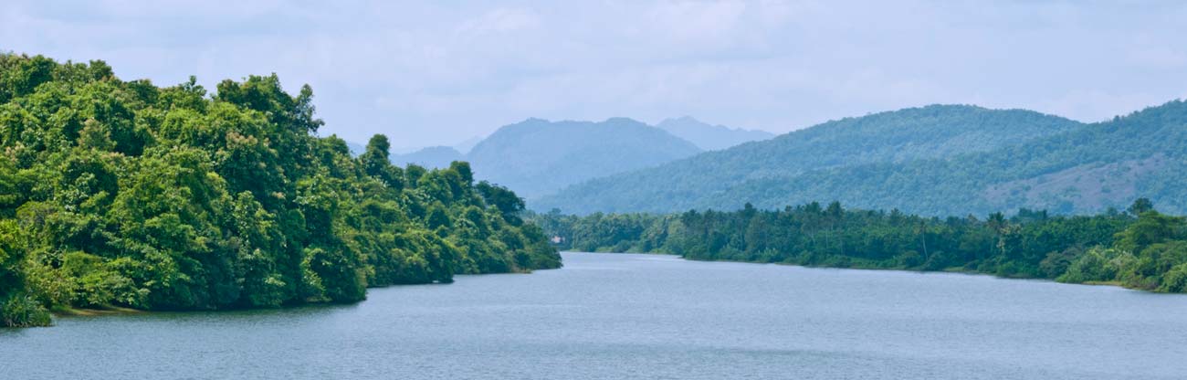
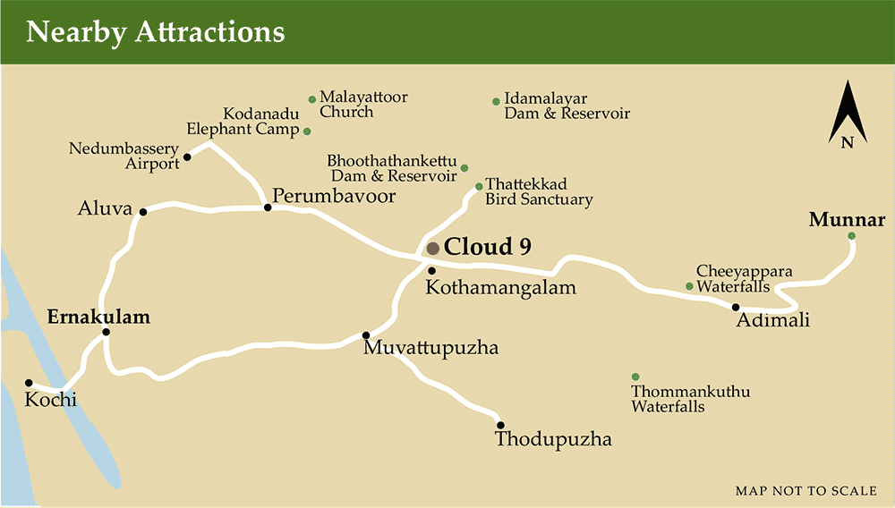
Apart from being the major transit point between Cochin and Munnar, Kothamangalam is a destination in itself, being on the foothills of Western Ghats with several scenic spots around.
| Distances to nearby Locations | ||
|---|---|---|
| Thattekkad Bird Sanctuary | : | 15km |
| Thommankuthu Waterfalls | : | 33km |
| Edamalayar Dam and Reservoir | : | 27km |
| Bhoothankettu Dam and Reservoir | : | 12km |
| Malayattur Church | : | 33km |
| Kodanad Elephant Camp | : | 22km |
| Cheeyappara Waterfalls | : | 32km |
| Paniyeli Poru Riverfront | : | 19km |
| Munnar | : | 76km |
| Nearest Amenities | ||
| Kochi Airport (Nedumbassery) | : | 34km |
| Aluva Railway Station | : | 35km |
| Ernakulam Railway Station | : | 45km |
Munnar
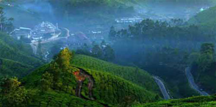
Munnar hills is siatuated at an altitude of 5000 to 8000 Ft above sea level. and is situated at the confluence of three mountain streams - Mudrapuzha, Nallathani & Kundala. This beautiful hill station was once the summer resort of the erstwhile British Government in South India. Sprawling Tea plantations, picture book towns, winding lanes, and holiday facilities make this a popular resort town. Munnar also has the highest peak in South India - Anamudi , which towers over 2695 m. Anamudi is an ideal spot for trekking. The high ranges of Munnar were earlier known as Kannan Devan Hills,named after a certain Kannan Devan,who had been land lord in the Anchanad Valley on the eastern side of the district. The main cultivation crops in Munnar are Tea and Coffee.
Location : Munnar, the nature lover's paradise, is located 130 kms away from Cochin at an altitude of 1600 mts above sea level.

Attractions :
This green hill station is surrounded by the country's highest tea gardens. Layers and layers of tea estates, mountain mist, waterfalls and wildlife sanctuaries make Munnar almost surrealistically beautiful. The lofty mountain ranges with misty peaks, sprawling tea estates and serene climate provides a quite and peaceful resort. This little sleepy village atop the western ghats is situated at the confluence of three mountain streams namely Mudrapuzha, Nallathanni and Kundala.
Panoramic views of lowflying clouds and mistfilled valleys make it a pretty little heaven with a cool, bracing climate. Misty mountain peaks blend harmoniously in Munnar to create a blissful atmosphere that is hard to describe.
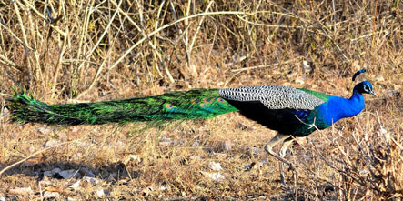
Munnar is also famous for the wild orchids locally called Neelakurinchi which blooms once in 12 years. During this time the entire valley turns violet. It is also home to Nilagiri tahr, a rare breed of mountain goat. Munnar was once the summer resort of the British government in South India; it still wears the old charm of the British plantation days.Munnar has a variety of attractions to feast your eyes like placid lakes, meandering streams, misty mountain peaks, sylvan valleys, rare orchids and wildlife.
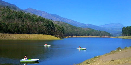
Plantation visits, treks, tea factory visits, cycling, boating, paragliding, day tours to the Periyar Wildlife Sanctuary etc. add to the excitement. Here you can also have a glimpse of gaur, langur, liontailed macaque, elephants and Nilgiri tahr that roam the stretch of grasslands or are seen climbing the pinnacles of the undulating hills.
Thattekkad
In the 19th Century when the British started various types of plantations, the Kannan Devan Hills (now known as Munnar) was one of their main targets for tea plantations in Kerala. To facilitate transport a road was constructed connecting Kannan Devan Hills with Cochin through the western slopes of the Western Ghats. The actual Ghat section of the road started from the right bank of the Periyar river, the second largest river in Kerala. Along the road many travellers' bungalows were constructed, Thattakad being first on the right bank of the river. The British also started the first large scale rubber plantations at 'Palamattam', close to Thattakad. In the early 1930s when Salim Ali was on his way to the high ranges of the Western Ghats during the Ornithological Survey of Travancore and Cochin, he came through the Old Munnar road. Thattakad being the starting place of the Ghat, Slim Ali selected it as one of his bird collection centres. Salim Ali noted the avifaunal diversity of Thattakad as one among the richest in his survey report. Unfortunately, the area had been exploited for cultivation, first, by the British and later by the locals. After independence some of these unauthorised encroachments were taken over by the Government and vast areas were planted with teak. In the 1980s the Kerala Government proposed to establish a bird sanctuary and asked Dr. Salim Ali for advice. He immediately suggested that Thattakad should be the first Bird Sanctuary of Kerala. As a result during 1983 an area of 25.16 Sq.Km was declared as a Bird Sanctuary. An intensive study on the flora and fauna of Thattakad Bird Sanctuary in Kerala was started in March 1994. The project is being funded by the 'Salim Ali Wild Wings Trust, Zoological Research Station, Thattakad Bird Sanctuary, Njayapitty, Kerala. Kerala Forest Department (Wildlife) with a view to study the biodiversity of the area and population size of the various components for the preparation of a scientific management plan. Some of the data furnished below were obtained during the project work.
STUDY AREA
Thattakad Bird Sanctuary (10- 10'N,76-40'- 76o 45'E) has an area of 25.16 Sq.Km and is bordered by the Periyar and Kuttampuzha rivers on two sides and Kolombathodu and Orulamthanni on the other two sides. It is almost at the foot of the western slopes of the Western Ghats and the altitude ranges from 50-250 Ain above msl. The highest point in the Western Ghats, the Anamudi Peak (2695 m), is directly uphill of Thattakad. The terrain is undulating and includes two high peaks called Thoppimudi and Njayapillimudi. Theriverbankhas been submerged for about 6 to 10 in by the water body created by an irrigation project, the Bhoothathankettu barrage oil the main stream of Periyar river. This has destroyed almost all the luxuriant riverain forest which existed along the banks. About 1/3 of the total Sanctuary area is under monoculture, mainly of teak and mahogany. The remaining forest consists of partly disturbed evergreen, semi-evergreen, moist deciduous Eeta (Ochlandra travancorica) forests, and grassland with rock outcrops or even land holdings ranging from 50.02 hectares to 4.05 to 6.07 hectares or even more along the fringes of the Sanctuary. However, there are no settlements inside the Sanctuary . Since the declaration of the area as a Sanctuary in 1983, there has been no regular forestry extraction and plantation activities inside the Sanctuary area. As a result, there is fairly thick forest undergrowth everywhere, including in the plantations. The area was under Malayatoor forest division before the declaration of the Sanctuary but is now under Idukki Wildlife division. The climate is hot and humid. The mean annual temperature varies from 18°C to 37°C. Rainfall is received both during Southwest and Northeast monsoon seasons. Ilowever, nearly 75% of the precipitation occurs luring the Southwest monsoon, from June to mid September. January and February are generally dry months. The average rainfall is 3000 mm. Strong winds with a speed of over 60 km per hour are common during the monsoon. The controversial Pooyamkutty Hydroelectric project area is very close io Thattakad Bird Sanctuary.
AVIFAUNA
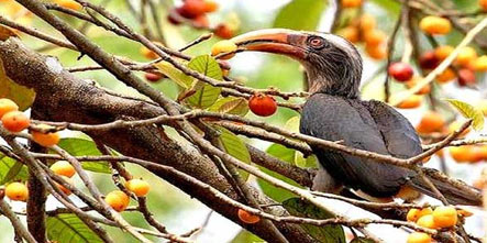
Thattakad was described as the 'richest bird habitat in peninsular India' by the late Salim Ali. 14c reported 163 species of birds from Thattakad alone during the 1930s survey. These were mostly Tropical forest species. Salim Ali (1936) in his report JBNHS 37 (4): 935-836 states "The forest which is principally Confined to the right bank of the river, consists in patches of both deciduous and tropical evergreen with frequently a mixture of the two. On the right Iiiink of the river also, there is a series of plantations (if die Forest Department: Teak, Rubber andBombax. I'lic first is about 6 years old, mostly devoid of undergrowth and poor in bird life. The rubber is about 25 years old, but owing to default of the contractor the weeding has not been done for some years with the result that Lantana, 'Incha' and a host of other species have overrun the place fit Impenetrable denseness. This area is the best of the iliree as regards birds. TbeBonibax plantations (0.25 hectare) is only one year old and little more than a lorest clearing so far. When the trees are old enough lo flower, this place will become a paradise for the iii-dwatcher. "Along the banks of Periyar River, and those d'flie many small streams that flow into it, are dense lumps ofEeta i.e.Ochlandra travancorica and they re likewise often lined with 'Ome' trees Trema rientalis whose berries are a great attraction to a]) frugivorous birds.
"No waterbirds were seen except Kingfishers, Attl('oltigi-qvii,AnhiriganwlanogasteraindMotacilia niath-raspayeruis which were usually present in small numbers. The country hereabouts is stiff with wild elephants and bird collection often provided unexpected thrills". Comparing this with the present status of these areas, we find that most of the natural types have degraded due to constant human interference and cattle grazing. Rubber and Bombax plantations are completely replaced with teak plantations. Lantana undergrowth is absent inside the sanctuary. Bombax plants are very few in number and there is no natural regeneration of this species inside the sanctuary. Eeta has almost vanished from the riverside due to formation of the lake. Even though it exists inside the sanctuary in some isolated patches, it is much thinned out due to over-extraction for commercial purposes and from forest fires. `Ome' (Trema orientalis) has also become uncommon due to the regular management practices for the protection of teak plantations.
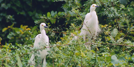
After the creation of the lake, a considerable increase in water bird population was noticed. Over 30 species of water birds alone have been recorded from Thattakad now. Their population shows an increasing trend now. The elephant which was common during Salim Ali's survey was totally absent from the area for a long time, but has now started reappearing during a certain season. During his survey there was no water bird habitat in Thattakad except for the two rivers. Since the 1960s conditions have clwAfiged entirely. There is a large water body constituted by the Boothankettu Dam. The depth of the water varies from 1.82 m to 35 m. Water vegetation has established itself over a substantial area providing facilities for water birds to feed and breed, thereby increasing the total population of the avifauna of Thattakad by at least 10 to 15%, Presently, there are about 270 species of birds reported from Thattakad. About 40% of the total species are migratory, while the others are resident or local migrants. Some are very rare, with only one or two sight records while others are very common. There are also species which were recorded as common by Salim Ali during 1930's which have become very rare or totally absent. The Great Indian Hornbill, Malabar Pied Hornbill, Laughing Thrush, etc. were recorded as common during the thirties, but have now completely vanished from the study area. There is a fairly good population of birds Re Malabar Trogon, Shama, Frogmouth. The peninsular Bay owl which has only been recorded from Parambikulam so far was noticed in Thattakad also. The Black Crested Baza is a breeding resident of this area. Water birds like the Little Cormorant, Large Cormorant, Darter, Shag, Dabchick, Whistling Teal, Bluewinged Teal, Pintail duck, etc. were not recorded by Salim Ali but have now become very common birds in the water spread area. The Openbill Stork and Purple Heron have made their appearance only two years ago. The Pheasant-tailed and the Bronzewinged Jacanas have started breeding in the water bodies in large numbers. In recent years, there is a seasonal influx of Terns such as the Common Tern, River Tern and the Whiskered Tern, with a population of over a thousand birds during winter migration. The Grey Jungle fowl and the Red Spur fowl population in the sanctuary is fairly good, whereas the quail population is low, even though more than one species are met with.
The large hole nesting birds have either vanished or are very few in numbers, indicating a lack of suitable nesting site. As for their food, it is abundant throughout the year. The frogmouth population was rare, as reported by Sugathan (1981) who conducted a frogmouth population survey during 1979 in the Western Ghats. After 1984, when the area came under the Wildlife Protection Act bamboo and Eeta cutting was completely stopped. The vegetation has now become re-established, enabling frogmouth to increase in numbers. Small sunbirds are one of the altitudinal migrants to the sanctuary in large numbers during November December every year. Similarly, the Blossombeaded and Roseringed parakeets make their appearance in Thattakad only during August-September in large numbers. Among the long distance migrants, warblers and flycatchers arrive first. We also get a transit population of flycatchers. A large population of warblers stay back for a long duration. Wagtails like forest wagtails, grey wagtails, etc. are some of the migratory species which stay fora long time. Kingfishers and bee-eaters nest on the loose sand deposits along the river bed in fairly good numbers. Drongos are common except for the Haircrested Drongo. Owls are many and most of them are breeding residents of the area. Among the swifts and swallows the Eastern Swallow is worth mentioning. They come in thousands during certain days and roost on telegraph and electric wires around the sanctuary. The sanctuary has a small breeding population of the Crested Tree Swift. The recent appearance of Bluewinged teals and Pintail ducks are interesting additions to the fauna. Larger populations of these species have been recorded from Vembanad lake for many years, which lies at a distance of about 35 km as the crow flies from the sanctuary. This year's trend indicates that their population at Thattakad will increase during the coming years. A detailed study on the population, habitat preference and reasons for disappearances and appearances of certain other species is in progress under the 'Ecology of Thattakad Project'.
Thommankuthu Waterfalls
This seven-step waterfalls, 33km from Kothamangalam, is set in the midst of dense forests is an ideal picnic spot.
Cheeyappara Waterfalls
On the highway to Munnar, 32km rom Kothamangalam, this waterfalls is an excellent stopover. Stallsnearby sell snacks and refreshments. Valara waterfallsis closeby.
Bhoothathakettu Dam and Reservoir
12km from Kothamangalam, a natural dam has been supplemented by a man-made dam across river Periyar. The calm waters of the reservoir are ideal for boating with the large boulders in the backdrop.
Idamalayar Dam and Reservoir
27km from Kothamangalam, this area, further up river Periyar is another spot for a day’s trip.